McClellan Creek National Grassland
- Nature & parks
- Near Amarillo, Texas
- 1.9 mi from Route 66
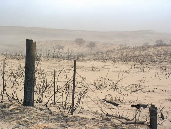
Set in southern Gray County, TX, McClellan Creek National Grassland covers a small patch of federal land set around McClellan Lake, a reservoir on McClellan Creek. The land was bought to heal badly eroded ground and let it return to a natural state. In 2006 a massive wildfire burned the whole area. It is a quiet, open-country break from the highway, with restrooms and parking on site.
What is McClellan Creek National Grassland?
At just 1,449 acres, this is one of the smaller units in the national grassland system. The U.S. Forest Service manages it jointly with Cibola National Forest and the Kiowa, Rita Blanca and Black Kettle National Grasslands, with a shared headquarters in Albuquerque. Day-to-day, it falls under a ranger district that pairs it with Black Kettle, with offices in Cheyenne, Oklahoma.
History of McClellan Creek National Grassland
The grassland began as a conservation project: badly worn land was purchased so it could be restored. In February 2006 the Interstate 40 fire swept across about 750,000 acres of the region and burned the entire grassland. Most of the trees were lost, so the landscape today reflects recovery from that fire.
Visiting McClellan Creek National Grassland: tips
Plan on an hour or so for a walk and a look at the lake. The site is listed as having restrooms, parking and wheelchair access. Bring water and sun protection, since shade is limited after the fire. The Leaning Tower of Britten is about 12 miles away if you want a roadside photo stop on the way back to the highway.
Practical info
- Address
- Texas
- Phone
- +1 580-497-2143
- Hours
- We have no opening hours for this stop yet — check the official site.
- On site & nearby
Sources: OpenStreetMap contributors (ODbL) · Wikidata · official site — may be outdated. Suggest a fix
On the map
Full mapMcClellan Creek National Grassland with the 6 closest stops. Tap a marker for details.
Tap a dot to see that stop here.
Stops near McClellan Creek National Grassland
All of Texas
11.9 mi from McClellan Creek National Grassland

15.5 mi from McClellan Creek National Grassland
35.2 mi from McClellan Creek National Grassland
.jpg/500px-Route_66_Bridge_over_Railroad%2C_Wheeler_County%2C_TX%2C_US_(07).jpg)
43.2 mi from McClellan Creek National Grassland

46.8 mi from McClellan Creek National Grassland

49.6 mi from McClellan Creek National Grassland
Own or run McClellan Creek National Grassland? Send us a photo or a correction.