14 days · 8 states

Route 66 itinerary: 14 days from Chicago to Santa Monica

Updated October 2026

Two weeks is the sweet spot for Route 66: long enough to drive the whole road from Chicago to Santa Monica without rushing, short enough to fit into one vacation. This itinerary splits the roughly 2,448 miles into 14 days of about 175 miles each, which leaves time to stop, look around and eat somewhere that is not a chain.

Customize this trip in the planner

Change the days, the pace or the kinds of stops. Nothing to sign up for.

Tap a dot to see that stop here.

Every stop of the 14 days on one map. Tap a dot for the photo and a link to the stop, or open the plan to see each day's route.

It is built by the same engine as our trip planner, from our map of 823 stops. Every night ends in a town with places to stay, most of them the main overnight towns on the road, such as Springfield, Springfield, Tulsa, Oklahoma City and Amarillo. Each day then gets the best stops on its stretch, chosen from facts: Route 66 icons first, then a mix of kinds, so a day is not all museums or all gas stations, and a long empty stretch gets a stop to break it up.

Use it as a starting point. Daily miles are measured along the old road and rounded, and the driving times assume an average of 45 mph, because much of Route 66 is two-lane road through small towns. Allow extra time in the big cities at each end. If you have more or fewer days, want a slower pace, or care more about museums than neon, open the plan in the planner: it rebuilds the days, the overnight towns and the stops, and sends the trip to Google Maps or a GPX file for your phone.

Day 1Chicago to Springfield

About 216 mi · about 4 h 45 min driving · 5 stops · Sleep in Springfield, IL

Gemini Giant in Wilmington, IL

Gemini Giant

Wilmington, Illinois · on Route 66

A fiberglass astronaut holding a rocket, standing beside Route 66 in Wilmington.

Art & landmarksPhoto credit
Ambler's Texaco Gas Station in Dwight, IL

Ambler's Texaco Gas Station

Dwight, Illinois · on Route 66

A house-style filling station in Dwight that sold gas on Route 66 for 66 straight years.

Retro roadsidePhoto credit
Standard Oil Gasoline Station in Odell, IL

Standard Oil Gasoline Station

Odell, Illinois · on Route 66

A restored 1932 house-and-canopy gas station in Odell, on the National Register of Historic Places.

Retro roadsidePhoto credit
Shea's Gas Station Museum in Springfield, IL

Shea's Gas Station Museum

Springfield, Illinois · on Route 66

A former Route 66 gas station museum in Springfield whose collection was auctioned off in 2015.

MuseumPhoto credit
President Abraham Lincoln Hotel in Springfield, IL

President Abraham Lincoln Hotel

Springfield, Illinois · 0.1 mi from Route 66

A downtown Springfield hotel linked by tunnel to the convention center, steps from the Old State Capitol.

Historic hotelPhoto credit

Plus 1 more stop in the planner. Open day 1 in the planner for every stop on this stretch, directions and a map of the day.

Day 2Springfield to Cuba

About 194 mi · about 4 h 15 min driving · 5 stops · Sleep in Cuba, MO

Ariston Cafe in Litchfield, IL

Ariston Cafe

Litchfield, Illinois · on Route 66

A 1935 restaurant on Old Route 66 in Litchfield, listed on the National Register and still a meal stop.

Retro roadsidePhoto credit
Soulsby Service Station in Mount Olive, IL

Soulsby Service Station

Mount Olive, Illinois · on Route 66

Mount Olive's 1926 house-and-canopy gas station, counted as the oldest usable station on Illinois Route 66.

Retro roadsidePhoto credit
Chain of Rocks Bridge in St. Louis, MO

Chain of Rocks Bridge

St. Louis, Missouri · 0.3 mi from Route 66

A Mississippi River crossing with a sharp bend in the middle, once part of Route 66 and now open to walkers.

Historic bridgePhoto credit
Gateway Arch in St. Louis, MO

Gateway Arch

St. Louis, Missouri · 0.7 mi from Route 66

The 630-foot steel arch on the Mississippi is the tallest arch on Earth and the symbol of St. Louis.

Art & landmarksPhoto credit
Meramec Caverns in Sullivan, MO

Meramec Caverns

Sullivan, Missouri · 1.9 mi from Route 66

Missouri's most-visited cave, a 4.6-mile system advertised by dozens of billboards along I-44.

Nature & parksPhoto credit

Open day 2 in the planner for every stop on this stretch, directions and a map of the day.

Day 3Cuba to Springfield

About 154 mi · about 3 h 30 min driving · 5 stops · Sleep in Springfield, MO

Wagon Wheel Motel, Café and Station in Cuba, MO

Wagon Wheel Motel, Café and Station

Cuba, Missouri · on Route 66

A Tudor Revival Route 66 motel in Cuba that has rented rooms without a break since 1938.

Retro roadsidePhoto credit
National Bank of Rolla Building, Missouri

National Bank of Rolla Building

Rolla, Missouri · 0.3 mi from Route 66

A 1931 Colonial Revival bank building in Rolla, listed for its role in the town and on Route 66.

Historic hotelPhoto credit
Uranus Missouri in St. Robert, MO

Uranus Missouri

St. Robert, Missouri · 0.1 mi from Route 66

A tongue-in-cheek roadside stop with a planet-pun name, a self-styled mayor and a record-setting belt buckle.

Route 66 sitePhoto credit
Munger-Moss Motel in Lebanon, MO

Munger-Moss Motel

Lebanon, Missouri · on Route 66

A Lebanon motel with roots in a 1930s Route 66 sandwich shop that moved here after World War II.

Retro roadsidePhoto credit
Dickerson Park Zoo in Springfield, MO

Dickerson Park Zoo

Springfield, Missouri · 1.0 mi from Route 66

Springfield's zoo, founded in 1922, with more than 500 animals from about 160 species.

Nature & parksPhoto credit

Open day 3 in the planner for every stop on this stretch, directions and a map of the day.

Day 4Springfield to Tulsa

About 211 mi · about 4 h 45 min driving · 5 stops · Sleep in Tulsa, OK

Boots Motel in Carthage, MO

Boots Motel

Carthage, Missouri · on Route 66

A 1939 streamline motor court in Carthage with black glass trim, green neon and a carport for every room.

Retro roadsidePhoto credit
66 Drive-In in Carthage, MO

66 Drive-In

Carthage, Missouri · 0.1 mi from Route 66

A 1949 drive-in theater on Route 66 near Carthage that still shows movies under the stars.

Retro roadsidePhoto credit
Picher, Oklahoma

Picher

Picher, Oklahoma · 2.7 mi from Route 66

A lead and zinc boomtown emptied by poisoned ground, cave-in danger and a 2008 tornado, now a ghost town.

Ghost townPhoto credit
Afton Station Packard Museum, Oklahoma

Afton Station Packard Museum

Afton, Oklahoma · on Route 66

A restored 1930s D-X station in Afton that housed Packards, old pumps and Route 66 memorabilia.

MuseumPhoto credit
Blue Whale of Catoosa, Oklahoma

Blue Whale of Catoosa

Catoosa, Oklahoma · 0.1 mi from Route 66

A big blue whale on the water's edge in Catoosa, one of the most recognized sights on old Route 66.

Art & landmarksPhoto credit

Open day 4 in the planner for every stop on this stretch, directions and a map of the day.

Day 5Tulsa to Oklahoma City

About 119 mi · about 2 h 45 min driving · 5 stops · Sleep in Oklahoma City, OK

Route 66 Historical Village in Tulsa, OK

Route 66 Historical Village

Tulsa, Oklahoma · on Route 66

An open-air stop on Southwest Boulevard with a tall oil derrick, a steam locomotive and a big Route 66 map.

MuseumPhoto credit
West Sapulpa Route 66 Roadbed, Oklahoma

West Sapulpa Route 66 Roadbed

Sapulpa, Oklahoma · 0.1 mi from Route 66

A stretch of old Route 66 roadbed in Sapulpa, listed on the National Register of Historic Places.

Route 66 sitePhoto credit
Rock Café in Stroud, OK

Rock Café

Stroud, Oklahoma · on Route 66

A 1930s sandstone cafe on Stroud's stretch of Route 66, rebuilt after a fire and tied to Pixar's Cars.

Retro roadsidePhoto credit
Seaba's Filling Station in Warwick, OK

Seaba's Filling Station

Warwick, Oklahoma · on Route 66

A 1920s brick DX filling station on the old Route 66 west of Chandler, listed on the National Register.

Retro roadsidePhoto credit
Oklahoma City Zoo and Botanical Garden, Oklahoma

Oklahoma City Zoo and Botanical Garden

Oklahoma City, Oklahoma · 1.6 mi from Route 66

A big city zoo and garden with more than 2,000 animals, a good family break from long Route 66 miles.

Nature & parksPhoto credit

Open day 5 in the planner for every stop on this stretch, directions and a map of the day.

Day 6Oklahoma City to Shamrock

About 175 mi · about 4 h driving · 5 stops · Sleep in Shamrock, TX

Milk Bottle Grocery in Oklahoma City, OK

Milk Bottle Grocery

Oklahoma City, Oklahoma · on Route 66

A tiny three-sided grocery crowned by a giant metal milk bottle on Oklahoma City's old Route 66 line.

Retro roadsidePhoto credit
North Canadian River Bridge in Oklahoma City, OK

North Canadian River Bridge

Oklahoma City, Oklahoma · on Route 66

A 1924 road bridge over the North Canadian River, listed on the National Register and tied to Route 66.

Historic bridgePhoto credit
Provine Service Station in Hydro, OK

Provine Service Station

Hydro, Oklahoma · on Route 66

Lucille's Place near Hydro, the station run for decades by the woman called the Mother of the Mother Road.

Retro roadsidePhoto credit
Casa Grande Hotel in Elk City, OK

Casa Grande Hotel

Elk City, Oklahoma · on Route 66

A four-story 1928 Spanish-style hotel in downtown Elk City, the only high-rise hotel for miles on Route 66.

Historic hotelPhoto credit
National Route 66 Museum in Elk City, OK

National Route 66 Museum

Elk City, Oklahoma · on Route 66

A museum named for the whole of Route 66, in the western Oklahoma town of Elk City.

MuseumPhoto credit

Open day 6 in the planner for every stop on this stretch, directions and a map of the day.

Day 7Shamrock to Amarillo

About 126 mi · about 2 h 45 min driving · 5 stops · Sleep in Amarillo, TX

Magnolia Service Station in Texola, OK

Magnolia Service Station

Texola, Oklahoma · on Route 66

A little house-style gas station in Texola, one of the last stops in Oklahoma for westbound drivers.

Retro roadsidePhoto credit
Route 66 Bridge over the Chicago, Rock Island and Gulf Railroad in Shamrock, TX

Route 66 Bridge over the Chicago, Rock Island and Gulf Railroad

Shamrock, Texas · on Route 66

A 1932 steel-and-concrete Route 66 bridge near Shamrock that still carries traffic over an old rail line.

Historic bridgePhoto credit
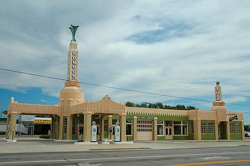
U-Drop Inn in Shamrock, TX

U-Drop Inn

Shamrock, Texas · on Route 66

Shamrock's Art Deco gas station and cafe, with twin flared towers, glazed tile walls and neon trim.

Retro roadsidePhoto credit
McClellan Creek National Grassland near Amarillo, TX

McClellan Creek National Grassland

Amarillo, Texas · 1.9 mi from Route 66

A small national grassland around McClellan Lake in the Texas Panhandle, recovering from a huge 2006 fire.

Nature & parksPhoto credit
Leaning Tower of Britten in Groom, TX

Leaning Tower of Britten

Groom, Texas · 0.1 mi from Route 66

A water tower tilted on purpose beside the highway in Groom, and a favorite of Route 66 photo books.

Art & landmarksPhoto credit

Open day 7 in the planner for every stop on this stretch, directions and a map of the day.

Day 8Amarillo to Tucumcari

About 129 mi · about 2 h 45 min driving · 5 stops · Sleep in Tucumcari, NM

U.S. Route 66-Sixth Street Historic District in Amarillo, TX

U.S. Route 66-Sixth Street Historic District

Amarillo, Texas · on Route 66

Amarillo's preserved stretch of Route 66 along Sixth Street, home of the old Amarillo Natatorium.

Route 66 sitePhoto credit
Cadillac Ranch in Amarillo, TX

Cadillac Ranch

Amarillo, Texas · 0.1 mi from Route 66

Ten old Cadillacs buried nose-first in a row in Amarillo, a 1974 artwork about the rise of the tail fin.

Art & landmarksPhoto credit
Midpoint Café in Adrian, TX

Midpoint Café

Adrian, Texas · on Route 66

The Adrian, TX, diner that marks the halfway point of Route 66, known for its "ugly crust" pies.

Retro roadsidePhoto credit
Glenrio, Texas

Glenrio

Glenrio, Texas · 0.2 mi from Route 66

A Route 66 ghost town split in two by the Texas–New Mexico line, just off I-40 at Texas Exit 0.

Ghost townPhoto credit
Blue Swallow Motel in Tucumcari, NM

Blue Swallow Motel

Tucumcari, New Mexico · on Route 66

A 1940s Tucumcari motor court with a glowing neon swallow and garages tucked between its rooms.

Retro roadsidePhoto credit

Open day 8 in the planner for every stop on this stretch, directions and a map of the day.

Day 9Tucumcari to Albuquerque

About 202 mi · about 4 h 30 min driving · 5 stops · Sleep in Albuquerque, NM

Metropolitan Park Bathhouse and Pool Historic District in Tucumcari, NM

Metropolitan Park Bathhouse and Pool Historic District

Tucumcari, New Mexico · 0.1 mi from Route 66

A 1940 Pueblo Revival bathhouse and pool in a landscaped Tucumcari park that locals call Five Mile Park.

Historic districtPhoto credit
Blue Hole near Santa Rosa, NM

Blue Hole

Santa Rosa, New Mexico · 0.3 mi from Route 66

A round, spring-fed pool near Santa Rosa where swimmers and scuba divers take the plunge.

Nature & parksPhoto credit
Tijeras Canyon, New Mexico

Tijeras Canyon

Tijeras, New Mexico · on Route 66

The mountain pass east of Albuquerque that Route 66, and now I-40, uses to cross the Sandia–Manzano range.

Nature & parksPhoto credit
Luna Lodge in Albuquerque, NM

Luna Lodge

Albuquerque, New Mexico · 0.1 mi from Route 66

A 1949 motor court at Albuquerque's eastern edge, rescued from ruin and turned into affordable apartments.

Retro roadsidePhoto credit
Lobo Theater in Albuquerque, NM

Lobo Theater

Albuquerque, New Mexico · on Route 66

A 1938 movie house on Central Avenue named for UNM's Lobos, back in business as an event venue.

Route 66 sitePhoto credit

Plus 1 more stop in the planner. Open day 9 in the planner for every stop on this stretch, directions and a map of the day.

Day 10Albuquerque to Gallup

About 153 mi · about 3 h 30 min driving · 5 stops · Sleep in Gallup, NM

ABQ BioPark Zoo in Albuquerque, NM

ABQ BioPark Zoo

Albuquerque, New Mexico · 0.6 mi from Route 66

Albuquerque's zoo since 1927, with Africa and Australia areas and a little train to the rest of the BioPark.

Nature & parksPhoto credit
Rio Puerco Bridge near Albuquerque, NM

Rio Puerco Bridge

Albuquerque, New Mexico · on Route 66

A 1933 steel truss with a 250-foot span that carried Route 66 west of Albuquerque, now open only to walkers.

Historic bridgePhoto credit
Charley's Automotive Service in Grants, NM

Charley's Automotive Service

Grants, New Mexico · on Route 66

A pumice-block garage, cafe and home from 1943 on Grants' stretch of Route 66, left much as it was.

Route 66 sitePhoto credit
Roy T. Herman's Garage and Service Station in Thoreau, NM

Roy T. Herman's Garage and Service Station

Thoreau, New Mexico · on Route 66

A 1935 Standard Oil station that moved to Thoreau in 1937 to serve a new stretch of Route 66.

Retro roadsidePhoto credit
El Rancho Hotel & Motel in Gallup, NM

El Rancho Hotel & Motel

Gallup, New Mexico · 0.1 mi from Route 66

A rustic 1937 Route 66 hotel in Gallup built by a movie director's brother, where Hollywood stars once stayed.

Historic hotelPhoto credit

Open day 10 in the planner for every stop on this stretch, directions and a map of the day.

Day 11Gallup to Flagstaff

About 215 mi · about 4 h 45 min driving · 5 stops · Sleep in Flagstaff, AZ

Painted Desert Inn near Holbrook, AZ

Painted Desert Inn

Holbrook, Arizona · 1.6 mi from Route 66

A 1937 Pueblo Revival lodge on the rim of the Painted Desert, now a National Historic Landmark.

Historic hotelPhoto credit
Wigwam Motel in Holbrook, AZ

Wigwam Motel

Holbrook, Arizona · 0.1 mi from Route 66

Fifteen concrete teepees from 1950 in Holbrook, AZ, still rented out to Route 66 travelers by one family.

Retro roadsidePhoto credit
Jack Rabbit Trading Post in Joseph City, AZ

Jack Rabbit Trading Post

Joseph City, Arizona · on Route 66

The yellow HERE IT IS sign and a big fiberglass jackrabbit have greeted Route 66 drivers since 1949.

Route 66 sitePhoto credit
Meteor Crater near Winslow, AZ

Meteor Crater

Winslow, Arizona · 5.4 mi from Route 66

A huge, remarkably well-preserved meteorite crater in the desert between Winslow and Flagstaff.

Nature & parksPhoto credit
Twin Arrows, Arizona

Twin Arrows

Twin Arrows, Arizona · on Route 66

An abandoned Route 66 trading post east of Flagstaff, named for the giant wooden arrows planted beside it.

Ghost townPhoto credit

Plus 1 more stop in the planner. Open day 11 in the planner for every stop on this stretch, directions and a map of the day.

Day 12Flagstaff to Kingman

About 177 mi · about 4 h driving · 5 stops · Sleep in Kingman, AZ

Lowell Observatory in Flagstaff, AZ

Lowell Observatory

Flagstaff, Arizona · 0.7 mi from Route 66

The Flagstaff observatory where Pluto was found in 1930, with a working 1896 telescope for public viewing.

Art & landmarksPhoto credit
Urban Route 66, Williams, Arizona

Urban Route 66, Williams

Williams, Arizona · on Route 66

Williams' main street is still lined with 1920s–1940s motels, gas stations and restaurants on old Route 66.

Route 66 sitePhoto credit
Delgadillo's Snow Cap Drive-In in Seligman, AZ

Delgadillo's Snow Cap Drive-In

Seligman, Arizona · on Route 66

Juan Delgadillo's 1953 joke-filled burger stand on Route 66 in Seligman, built from railroad scrap lumber.

Route 66 sitePhoto credit
Grand Canyon Caverns in Peach Springs, AZ

Grand Canyon Caverns

Peach Springs, Arizona · 0.1 mi from Route 66

A dry cave 210 feet underground just off Route 66 near Peach Springs, reached by elevator, reopened in 2025.

Nature & parksPhoto credit
Hackberry, Arizona

Hackberry

Hackberry, Arizona · 0.4 mi from Route 66

A tiny, near-empty community on the old road northeast of Kingman, counted among Arizona's ghost towns.

Ghost townPhoto credit

Open day 12 in the planner for every stop on this stretch, directions and a map of the day.

Day 13Kingman to Barstow

About 222 mi · about 5 h driving · 5 stops · Sleep in Barstow, CA

Oatman, Arizona

Oatman

Oatman, Arizona · on Route 66

A former gold camp in the Black Mountains that Route 66 still runs straight through.

Ghost townPhoto credit
66 Motel in Needles, CA

66 Motel

Needles, California · on Route 66

A six-room 1940s motel in Needles, with a 66 neon sign relit in 2012 in front of the old Carty's Camp cabins.

Route 66 sitePhoto credit
Roy's Motel and Cafe in Amboy, CA

Roy's Motel and Cafe

Amboy, California · 0.1 mi from Route 66

The 1959 boomerang sign and Googie lobby of Amboy, a Mojave gas stop on Route 66 first opened in 1938.

Retro roadsidePhoto credit
Amboy Crater, California

Amboy Crater

Amboy, California · 1.4 mi from Route 66

A dormant cinder cone rising from a dark lava field, a short detour south of Route 66.

Nature & parksPhoto credit
Bagdad, California

Bagdad

Bagdad, California · on Route 66

A vanished Mojave railroad town on Route 66 that holds the U.S. record for the longest dry spell.

Ghost townPhoto credit

Plus 1 more stop in the planner. Open day 13 in the planner for every stop on this stretch, directions and a map of the day.

Day 14Barstow to Santa Monica

About 153 mi · about 3 h 30 min driving · 5 stops · Finish in Santa Monica, CA

Elmer's Bottle Tree Ranch near Victorville, CA

Elmer's Bottle Tree Ranch

Victorville, California · on Route 66

More than 200 bottle trees on a two-acre desert ranch, created by Elmer Long beside Route 66 in Oro Grande.

Art & landmarksPhoto credit
California Route 66 Museum in Victorville, CA

California Route 66 Museum

Victorville, California · on Route 66

Victorville's Route 66 museum, set in the old Red Rooster Cafe right on D Street in Old Town.

MuseumPhoto credit
Wigwam Motel in Rialto, CA

Wigwam Motel

Rialto, California · on Route 66

Nineteen tipi-shaped rooms on old Route 66: the last of the seven Wigwam Villages, and one of three left.

Retro roadsidePhoto credit
Cucamonga Service Station in Rancho Cucamonga, CA

Cucamonga Service Station

Rancho Cucamonga, California · on Route 66

The last Route 66 gas station of its design left in California, right on Foothill Boulevard.

Retro roadsidePhoto credit
Colorado Street Bridge in Pasadena, CA

Colorado Street Bridge

Pasadena, California · on Route 66

A curving 1913 concrete arch bridge high over the Arroyo Seco that carried Route 66 traffic until 1940.

Historic bridgePhoto credit

Open day 14 in the planner for every stop on this stretch, directions and a map of the day.

Customize this trip in the plannerSee the best stops by state

Before you go

When to go

Spring and fall are the comfortable seasons, roughly April to June and September to October. In July and August the Mojave Desert in California and western Arizona is very hot: summer highs there are often above 100°F. In winter, snow is common in the high country around Flagstaff, which sits near 7,000 feet. The road turns 100 on November 11, 2026, so expect busier motels around the centennial and book ahead.

Finding the old road

Phone maps and car GPS tend to send you onto the interstates (I-55, I-44 and I-40), and the old road is not signed the whole way, because it is no longer a federal highway. Use our plan to know where to stop, and a turn-by-turn Route 66 guide or offline maps for the old alignments. The EZ66 Guide for Travelers, a widely used printed guide, gives turn-by-turn directions both westbound and eastbound.

A closed stretch in the Mojave

The old road between Essex and Amboy, California, has been closed since 2014 while its bridges are rebuilt; the work is expected to finish in 2027. The usual detour is Interstate 40 and Kelbaker Road. The stretch from Ludlow to Amboy, past Roy's, is open.

Water, fuel and heat

In the desert, carry at least a gallon of water per person per day, start each stretch with a full tank, and tell someone your route. If the car breaks down in the heat, stay with it. Cell signal can drop out for long stretches.

Ten days or three weeks instead

About ten days is the practical minimum for the old road; most guides suggest two to three weeks. The same trip in 10 days means longer drives, and in 21 days an easy pace with more stops; the planner rebuilds the days either way.

Route 66 itinerary: questions

How many days do you need to drive Route 66?
About two weeks is the most popular choice: 14 days at roughly 175 miles a day leaves time for the stops. About ten days is the practical minimum if you want the old road rather than the interstate; most guides suggest two to three weeks. The trip planner rebuilds this plan for any number of days.
Where do you stay overnight on this itinerary?
Every night ends in a town with places to stay, mostly the bigger overnight towns along the road: Springfield, IL, Cuba, MO, Springfield, MO, Tulsa, OK, Oklahoma City, OK, Shamrock, TX, Amarillo, TX, Tucumcari, NM, Albuquerque, NM, Gallup, NM, Flagstaff, AZ, Kingman, AZ and Barstow, CA, and finally Santa Monica, CA. Book ahead in summer, especially in the classic motel towns.
Should you drive Route 66 east to west or west to east?
Either works. Most travelers start in Chicago and drive west, the way the road is usually described, which saves the desert and the Pacific for the end. Driving east from Santa Monica works just as well; open the plan in the planner and swap the start and finish.
What is the best month to drive Route 66?
April to June and September to October: mild weather in the desert states, long days and most seasonal attractions open. High summer is very hot in the Mojave and western Arizona, and winter can bring snow around Flagstaff and in New Mexico.
Which is the longest day on this itinerary?
Day 13, from Kingman, AZ to Barstow, CA, at about 222 miles and about 5 h of driving. If that is too much, add a day in the planner and it splits the trip again.

More answers on the Route 66 facts page.