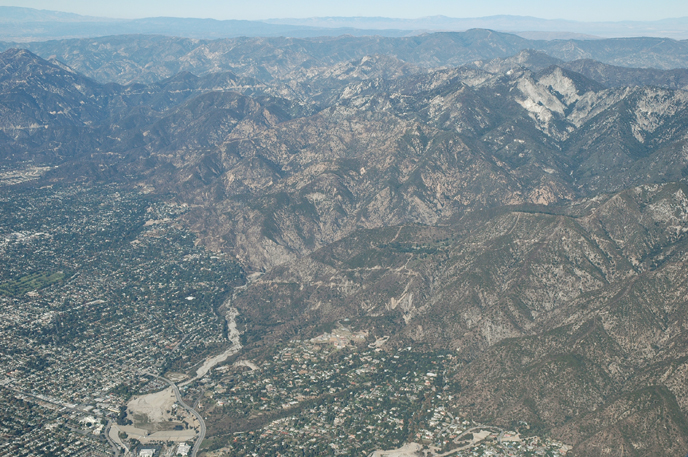
Eaton Canyon in Altadena, CA
Photo: Wikimedia Commons — see author and license on the file page.

Eaton Canyon

Eaton Canyon is a large canyon that drops out of the San Gabriel Mountains toward Pasadena, CA, about 4.1 miles off the old road. Its upper end lies at Eaton Saddle, close to San Gabriel Peak and Mount Markham, inside the Angeles National Forest. Most visitors know it through its nature center in Pasadena, a good place to get out of the car and into the foothills.

What is Eaton Canyon?

Water from the canyon flows into the Rio Hondo and on to the Los Angeles River. The name honors Judge Benjamin S. Eaton, who in 1865 made his home at the Fair Oaks Ranch House, not far from Eaton Creek.

Visiting Eaton Canyon: tips

Start at the nature center for the easiest access. The Mount Wilson Toll Road also begins in the canyon, for hikers who want a long climb; carry plenty of water. Gen. Charles S. Farnsworth County Park is about 2.5 miles away, and Little Santa Anita Canyon about 3.5 miles off.

Practical info

On site & nearby

Sources: OpenStreetMap contributors (ODbL) · Wikidata · official site — may be outdated. Suggest a fix

Where to eat near Eaton Canyon

All diners on Route 66 →
  • Twohey's in South Pasadena, CA
    Diner & restaurant

    Twohey's

    South Pasadena, CA · 6.8 mi from Eaton Canyon

    A 1950s-style diner in South Pasadena, founded in 1943 and known for a burger called the Little Stink-O.

  • Fair Oaks Pharmacy in South Pasadena, CA
    Diner & restaurant

    Fair Oaks Pharmacy

    South Pasadena, CA · 7.1 mi from Eaton Canyon

    A 1915 pharmacy with an old-fashioned soda fountain, on the corner where Route 66 ran down Fair Oaks Avenue.

  • Philippe's in Los Angeles, CA
    Diner & restaurant

    Philippe's

    Los Angeles, CA · 13.2 mi from Eaton Canyon

    A downtown Los Angeles restaurant running since 1908 that claims to have invented the French dip sandwich.

On the map

Full map

Eaton Canyon with the 6 closest stops and places to eat (fork and knife). Tap a marker for details.

Tap a dot to see that stop here.

Stops near Eaton Canyon

All of California
Gen. Charles S. Farnsworth County Park in Altadena, CA

Gen. Charles S. Farnsworth County Park

Altadena, California · 3.8 mi from Route 66

A 1930s foothill park in Altadena, listed on the National Register and hit hard by the 2025 Eaton Fire.

Nature & parksPhoto credit

2.5 mi from Eaton Canyon

The Bunny Museum near Pasadena, CA

The Bunny Museum

Pasadena, California · 1.6 mi from Route 66

A record-setting rabbit collection whose building burned in 2025, with plans to reopen.

MuseumPhoto credit

2.7 mi from Eaton Canyon

Little Santa Anita Canyon

Sierra Madre, California · 1.4 mi from Route 66

A mountain canyon above Sierra Madre where the Mount Wilson Trail begins its climb.

Nature & parks

3.5 mi from Eaton Canyon

Saga Motor Hotel

Pasadena, California · 0.1 mi from Route 66

A 1959 motor hotel on Pasadena's Route 66, with a neon sign that still lights up and a palm-shaded pool.

Historic hotel

4.4 mi from Eaton Canyon

Los Angeles County Arboretum and Botanic Garden in Arcadia, CA

Los Angeles County Arboretum and Botanic Garden

Arcadia, California · 0.4 mi from Route 66

127 acres of gardens and historic grounds in Arcadia, set against the foothills of the San Gabriels.

Nature & parksPhoto credit

4.8 mi from Eaton Canyon

Pacific Asia Museum in Pasadena, CA

Pacific Asia Museum

Pasadena, California · 0.1 mi from Route 66

Asian and Pacific art inside a 1920s building styled like a Chinese imperial palace in Pasadena.

MuseumPhoto credit

5.0 mi from Eaton Canyon

Own or run Eaton Canyon? Send us a photo or a correction.