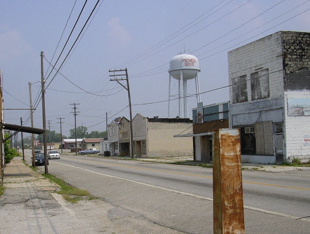
Picher, Oklahoma
- Ghost town
- In Picher, Oklahoma
- 2.7 mi from Route 66
Picher, in Ottawa County, OK, about 3 miles off Route 66, grew up on the most productive lead and zinc field in the Tri-State district and once had more than 14,000 people. Mining left the ground hollow and the town ringed by toxic waste piles called chat. After a federal and state buyout and a deadly 2008 tornado, Picher stopped operating as a city in 2009. It is now a ghost town inside the Tar Creek Superfund site.
What is Picher?
Picher today is mostly empty lots, cracked pavement and gray mounds of chat, the gravel-like mill waste laced with lead, zinc and cadmium. Most houses and businesses were torn down after the buyout. The area lies inside the Tar Creek Superfund site, which the EPA has been working on since the 1980s; some chat piles have been hauled off or reduced, but the agency expects the cleanup to take decades more.
History of Picher
The town sprang up almost overnight in late 1913 around a lead and zinc strike and took its name from O. S. Picher, who owned the Picher Lead Company. It incorporated in 1918 and reached its peak population in 1926. The Picher field supplied a large share of the lead and zinc the country used in World War I.
When mining ended in 1967 the pumps stopped, the mines flooded, and acid water began seeping into Tar Creek in the 1970s. The area became a Superfund site in 1983. Studies found lead poisoning among local children, and an Army Corps of Engineers study in 2006 found that nearly nine in ten buildings in town could suddenly collapse. A buyout followed, and nearly everyone left. In May 2008 a powerful tornado tore through town and killed at least six people. The high school graduated its last class in 2009, and the city stopped operating on September 1, 2009; its charter was formally dissolved in November 2013.
Visiting Picher: tips
Picher can be seen from public roads, mainly U.S. 69, which still runs through it about 8 miles north of Miami. It is not a park or a managed attraction: bought-out lots carry deed notices and pass in the end to the Quapaw Nation, so do not trespass; the ground may be undermined and the chat holds lead. Stay on the road, keep off the piles, do not enter buildings or fenced areas and take nothing away. Cardin and Zincville are each about 1.3 miles away and Douthat about 1.7 miles, so one short loop covers the district's ghost towns before rejoining Route 66 at Commerce or Quapaw.
Practical info
- Address
- Oklahoma 74360
Sources: OpenStreetMap contributors (ODbL) · Wikidata · official site — may be outdated. Suggest a fix
On the map
Full mapPicher with the 6 closest stops. Tap a marker for details.
Tap a dot to see that stop here.
Stops near Picher
All of Oklahoma
1.3 mi from Picher
1.3 mi from Picher

1.4 mi from Picher
1.7 mi from Picher
.jpg/500px-Hockerville%2C_Oklahoma_(1918).jpg)
2.9 mi from Picher

4.6 mi from Picher
Questions about Picher
Can you visit Picher, Oklahoma?
You can drive through on U.S. 69 and see the chat piles and empty lots from public roads, but Picher is not a tourist attraction. Bought-out lots carry deed notices and are not for public use, the ground may be undermined, and the mine waste contains lead. Stay on the road, keep off the piles and take nothing home.
What happened to Picher, Oklahoma?
Decades of lead and zinc mining left Picher on hollow ground beside huge piles of toxic waste. After the area became a Superfund site in 1983, studies found lead poisoning in children and buildings at risk of collapse. A federal and state buyout emptied the town, a May 2008 tornado sped the exodus, and Picher stopped operating as a city in 2009.
Does anyone still live in Picher?
Almost no one. The 2010 census counted 20 people within the old town limits, and a 2014 national news report found about 10 holdouts still there. Nearly every other resident took the buyout, and most of the town's buildings have since been demolished.
Own or run Picher? Send us a photo or a correction.