56 stops · 8 states

Ghost towns on Route 66

Ghost towns are the Route 66 stops people ask about most after the old motels, and there are 56 of them in our data, spread over all 8 states. By state: Illinois 3, Missouri 22, Kansas 1, Oklahoma 7, Texas 2, New Mexico 1, Arizona 9, California 11.

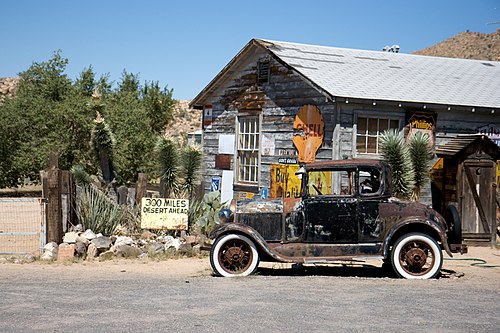
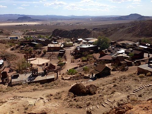
The best-known ones are in the desert West: Oatman, Arizona, where the road climbs through the mountains between Kingman and the Colorado River, and the string of near-empty Mojave stops in California — Amboy, Bagdad, Essex, Chambless, Ludlow and Siberia — plus the old mining town of Calico near Barstow. Missouri has the most entries, but many of those are little more than a name on an old map. Oklahoma's Picher, Cardin and Douthat are former mining towns that emptied out, and Times Beach in Missouri was evacuated and is now parkland.

A typical ghost town sits about 2.4 mi off the road, often down a gravel lane. Practical hint: many of the remaining buildings are on private land, so look from the road, stay out of ruins, and carry water — in the Mojave there is no shade and little fuel between Needles and Barstow.

Tap a dot to see that stop here.

Tap a dot for the photo and a link to the stop. Open this kind on the full map to filter by state or add a stop to your trip.

Ghost towns in Illinois (3)

All of Illinois →

Tedens

Tedens, Illinois · 2.2 mi from Route 66

A vanished DuPage County community, best paired with nearby Lemont and Waterfall Glen.

Ghost town

Millsdale

Millsdale, Illinois · 3.7 mi from Route 66

A vanished railroad village near Joliet that counted only about two dozen residents in the 1900s.

Ghost town

Tracy

Tracy, Illinois · 3.6 mi from Route 66

A lost coal-mining town in Kankakee County that emptied out when its coal ran out around 1900.

Ghost town

Ghost towns in Missouri (22)

All of Missouri →
Times Beach, Missouri

Times Beach

Times Beach, Missouri · 0.4 mi from Route 66

A Route 66 town emptied by dioxin in 1983, its land now a state park that remembers the old road.

Ghost townPhoto credit

Arlington

Arlington, Missouri · 0.1 mi from Route 66

A near-empty railroad and Route 66 town on the Little Piney, left at a dead end when I-44 bypassed it.

Ghost town

Clementine

Clementine, Missouri · on Route 66

A tiny community right on the old Route 66 alignment, about fourteen miles southwest of Rolla.

Ghost town

Hooker

Hooker, Missouri · 0.2 mi from Route 66

A roadside town built on a newer line of Route 66, now gone except for its cemetery.

Ghost town

Sampson

Sampson, Missouri · 0.1 mi from Route 66

A tiny crossroads community in Webster County, between Niangua and Conway, northeast of Marshfield.

Ghost town

Holman

Holman, Missouri · on Route 66

A short-lived Webster County post-office town that once had its own schoolhouse, northeast of Springfield.

Ghost town

More ghost towns in Missouri 16

Ghost towns in Kansas (1)

All of Kansas →
Treece, Kansas

Treece

Treece, Kansas · 3.9 mi from Route 66

A Kansas mining town emptied by lead pollution; most of it was torn down by 2012.

Ghost townPhoto credit

Ghost towns in Oklahoma (7)

All of Oklahoma →
Hockerville, Oklahoma

Hockerville

Hockerville, Oklahoma · 1.9 mi from Route 66

A lead and zinc camp on the Kansas line, once home to 500-plus people and now an emptied Superfund ghost town.

Ghost townPhoto credit

Zincville

Zincville, Oklahoma · 2.5 mi from Route 66

A former mining camp between Picher and Hockerville, close to the Kansas line.

Ghost town
Picher, Oklahoma

Picher

Picher, Oklahoma · 2.7 mi from Route 66

A lead and zinc boomtown emptied by poisoned ground, cave-in danger and a 2008 tornado, now a ghost town.

Ghost townPhoto credit
Cardin, Oklahoma

Cardin

Cardin, Oklahoma · 2.2 mi from Route 66

A zinc and lead town that emptied after federal buyouts; its population reached zero in 2010.

Ghost townPhoto credit

Douthat

Douthat, Oklahoma · 1.1 mi from Route 66

An abandoned 1917 lead and zinc camp south of Picher, now empty and inside the Tar Creek Superfund site.

Ghost town

Hext

Hext, Oklahoma · 0.3 mi from Route 66

A small rural community in Beckham County, tucked between Interstate 40 and the old Route 66 business loop.

Ghost town

More ghost towns in Oklahoma 1

Ghost towns in Texas (2)

All of Texas →

Boise

Boise, Texas · 0.9 mi from Route 66

A quiet Texas ghost town at about 4,000 feet, south of Interstate 40 and east of Glenrio.

Ghost town
Glenrio, Texas

Glenrio

Glenrio, Texas · 0.2 mi from Route 66

A Route 66 ghost town split in two by the Texas–New Mexico line, just off I-40 at Texas Exit 0.

Ghost townPhoto credit

Ghost towns in New Mexico (1)

All of New Mexico →

Anaconda, New Mexico

Anaconda, New Mexico · 0.5 mi from Route 66

The vanished company town of a 1950s uranium mill beside Route 66 northwest of Grants.

Ghost town

Ghost towns in Arizona (9)

All of Arizona →
Brigham City, Arizona

Brigham City

Brigham City, Arizona · 1.4 mi from Route 66

The walled remains of an 1876 Mormon farming colony on the Little Colorado River, just north of Winslow.

Ghost townPhoto credit
Two Guns, Arizona

Two Guns

Two Guns, Arizona · on Route 66

A long-closed tourist stop on the rim of Canyon Diablo that faded once the interstate carried traffic past.

Ghost townPhoto credit
Canyon Diablo, Arizona

Canyon Diablo

Canyon Diablo, Arizona · 3.1 mi from Route 66

A railroad camp from 1880 with a wild reputation, now foundations, one grave and old bridge footings.

Ghost townPhoto credit
Twin Arrows, Arizona

Twin Arrows

Twin Arrows, Arizona · on Route 66

An abandoned Route 66 trading post east of Flagstaff, named for the giant wooden arrows planted beside it.

Ghost townPhoto credit
Hackberry, Arizona

Hackberry

Hackberry, Arizona · 0.4 mi from Route 66

A tiny, near-empty community on the old road northeast of Kingman, counted among Arizona's ghost towns.

Ghost townPhoto credit
Oatman, Arizona

Oatman

Oatman, Arizona · on Route 66

A former gold camp in the Black Mountains that Route 66 still runs straight through.

Ghost townPhoto credit

More ghost towns in Arizona 3

Ghost towns in California (11)

All of California →
Essex, California

Essex

Essex, California · 0.1 mi from Route 66

A small desert settlement on the old National Old Trails Road alignment, just south of I-40.

Ghost townPhoto credit
Amboy, California

Amboy

Amboy, California · 0.1 mi from Route 66

A near-empty desert town on Route 66, home of Roy's and close to Amboy Crater.

Ghost townPhoto credit
Bagdad, California

Bagdad

Bagdad, California · on Route 66

A vanished Mojave railroad town on Route 66 that holds the U.S. record for the longest dry spell.

Ghost townPhoto credit

Siberia

Siberia, California · 0.2 mi from Route 66

A former rail siding and Route 66 stop in the Mojave, now wiped almost completely from the desert floor.

Ghost town
Ludlow, California

Ludlow

Ludlow, California · 0.2 mi from Route 66

A desert stop dating to 1882, where Route 66 remains sit just off Interstate 40.

Ghost townPhoto credit
Calico, California

Calico

Calico, California · 6.1 mi from Route 66

An 1881 silver boomtown near Barstow, restored by Walter Knott and now a county park with mine tours.

Ghost townPhoto credit

More ghost towns in California 5