
Mitchell Archaeological Site
- Archaeology
- In Pontoon Beach, Illinois
- 3.9 mi from Route 66
- National Register of Historic Places
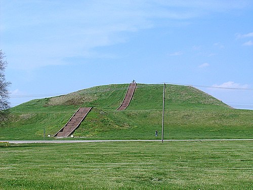
The Mitchell Archaeological Site near Pontoon Beach, IL, in Mitchell at the western tip of University Drive, holds a platform mound and traces of a village. Mississippian people lived here around 1150 to 1200, and in its day it was the biggest site in the Cahokia system apart from Cahokia. Most of it was destroyed when Interstate 270 was built, a reminder of what highways cost. It is about 4 miles off the old road.
What is Mitchell Archaeological Site?
What survives is a single platform mound plus traces of a village. There were once several more mounds, but modern building work wiped them out. Most of what is known about the place comes from salvage digs carried out just before the interstate went through.
History of Mitchell Archaeological Site
The site was lived in around 1150 to 1200. It belonged to the web of settlements around Cahokia and was second only to Cahokia in size. Construction of Interstate 270 later destroyed the larger part of it. It joined the National Register on February 7, 1978.
For Route 66 travelers the story has a familiar ring. The interstates changed the old road towns, and here one erased much of a far older community.
Visiting Mitchell Archaeological Site: tips
There is little to see beyond the mound, so treat this as a short, respectful stop and stay off the earthwork. The Horseshoe Lake Mound and Village Site is right beside it, Horseshoe Lake State Park about 1.9 miles away, and Mound 34 about 3.1 miles.
Practical info
- Address
- Pontoon Beach, IL 62040
- On site & nearby
Sources: OpenStreetMap contributors (ODbL) · Wikidata · official site — may be outdated. Suggest a fix
Where to eat near Mitchell Archaeological Site
All diners on Route 66 →
On the map
Full mapMitchell Archaeological Site with the 6 closest stops and a place to eat (fork and knife). Tap a marker for details.
Tap a dot to see that stop here.
Stops near Mitchell Archaeological Site
All of Illinois
0.0 mi from Mitchell Archaeological Site

1.9 mi from Mitchell Archaeological Site
3.1 mi from Mitchell Archaeological Site
3.5 mi from Mitchell Archaeological Site

3.7 mi from Mitchell Archaeological Site

7.0 mi from Mitchell Archaeological Site
Own or run Mitchell Archaeological Site? Send us a photo or a correction.