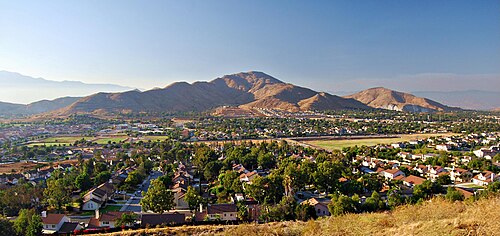
Jurupa Mountains in Jurupa Valley, CA
Photo: Wikimedia Commons — see author and license on the file page.

Jurupa Mountains

The Jurupa Mountains, also known as the Jurupa Hills, are a small range in Jurupa Valley, CA, about 5.9 miles off the old road. They rise in the southeastern Pomona Valley, spreading across parts of two counties, Riverside to the south and San Bernardino to the north. For Route 66 travelers crossing the Inland Empire, these hills are a nearby patch of open country and the home of Mount Jurupa, the range's highest summit.

What is Jurupa Mountains?

The range belongs to the Peninsular Ranges System, the family of mountains that runs south through Southern California. It is modest in size compared with the big ranges to the north.

Visiting Jurupa Mountains: tips

Plan an outdoor outing and bring water. Mount Jurupa, the high point, is about 1 mile away. Bono's Restaurant and Deli is about 5.3 miles away, and La Placita about 6.3 miles.

Practical info

Address
Jurupa Valley, CA 92509

Sources: OpenStreetMap contributors (ODbL) · Wikidata · official site — may be outdated. Suggest a fix

Where to eat near Jurupa Mountains

All diners on Route 66 →
  • Mitla Cafe in San Bernardino, CA
    Diner & restaurant

    Mitla Cafe

    San Bernardino, CA · 10.0 mi from Jurupa Mountains

    Family-run Mexican cafe on Mount Vernon Avenue, the old Route 66, open since 1937 and known for crisp tacos.

  • Diner & restaurant

    Sycamore Inn

    Rancho Cucamonga, CA · 10.7 mi from Jurupa Mountains

    A steakhouse in a 1920 inn on Foothill Boulevard, on a site that fed travelers long before Route 66 existed.

  • Magic Lamp Inn in Rancho Cucamonga, CA
    Diner & restaurant

    Magic Lamp Inn

    Rancho Cucamonga, CA · 10.9 mi from Jurupa Mountains

    A 1950s Route 66 steakhouse whose Aladdin's-lamp neon sign burns a real gas flame after dark.

On the map

Full map

Jurupa Mountains with the 6 closest stops and places to eat (fork and knife). Tap a marker for details.

Tap a dot to see that stop here.

Stops near Jurupa Mountains

All of California
Mount Jurupa in Jurupa Valley, CA

Mount Jurupa

Jurupa Valley, California · 5.2 mi from Route 66

The top of the Jurupa Mountains, with a summit trail and wide views over the Inland Empire.

Nature & parksPhoto credit

1.0 mi from Jurupa Mountains

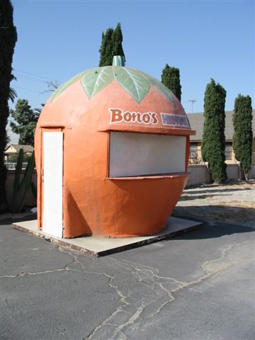
Bono's Restaurant and Deli in Fontana, CA

Bono's Restaurant and Deli

Fontana, California · on Route 66

A 1940s Streamline Moderne roadside restaurant in Fontana, with a giant orange juice stand on the lot.

Retro roadsidePhoto credit

5.3 mi from Jurupa Mountains

La Placita

La Placita, California · 6.0 mi from Route 66

The site of Riverside County's earliest community, settled on the Santa Ana River in the 1840s.

Ghost town

6.3 mi from Jurupa Mountains

Wigwam Motel in Rialto, CA

Wigwam Motel

Rialto, California · on Route 66

Nineteen tipi-shaped rooms on old Route 66: the last of the seven Wigwam Villages, and one of three left.

Retro roadsidePhoto credit

8.2 mi from Jurupa Mountains

Cucamonga Service Station in Rancho Cucamonga, CA

Cucamonga Service Station

Rancho Cucamonga, California · on Route 66

The last Route 66 gas station of its design left in California, right on Foothill Boulevard.

Retro roadsidePhoto credit

9.3 mi from Jurupa Mountains

Politana

Politana, California · 1.9 mi from Route 66

Where Spain first settled the San Bernardino Valley, starting as a mission outpost in 1810.

Ghost town

9.6 mi from Jurupa Mountains

Own or run Jurupa Mountains? Send us a photo or a correction.