Route 66 town guide · California

Route 66 in San Bernardino, California

San Bernardino is where Route 66 comes down from Cajon Pass into the Los Angeles basin, about 2,384 miles from Chicago. From here the old road runs west along Foothill Boulevard through Fontana, Rancho Cucamonga, Upland and Claremont, and the stops we group under San Bernardino follow that line.

Tap a dot to see that stop here.

Tap a dot for the photo and a link to the stop (the fork-and-knife markers are places to eat). Open San Bernardino on the full map to filter by kind or add stops to your trip.

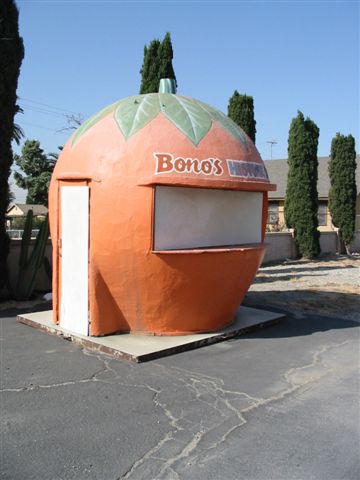
The Route 66 highlight is the Cucamonga Service Station on Foothill Boulevard, the last Route 66 gas station of its design left in California. In Fontana, Bono's Restaurant and Deli is a 1940s Streamline Moderne roadside restaurant, now closed, with a giant orange juice stand on its lot. History goes back to the ranchos: the Tapia Adobe marks the home site of Tiburcio Tapia, who held the 1839 Rancho Cucamonga land grant, and the 1860s John Rains House, with its tale of wine, debt and murder, is now a county history museum.

Claremont, at the west end of this stretch, is a college town with a lot to see on foot. At Pomona College, José Clemente Orozco's Prometheus, painted in 1930, is widely seen as America's earliest modern fresco, and the Benton Museum of Art opened in 2020. The California Botanic Garden spreads 86 acres of California native plants below the San Gabriel foothills.

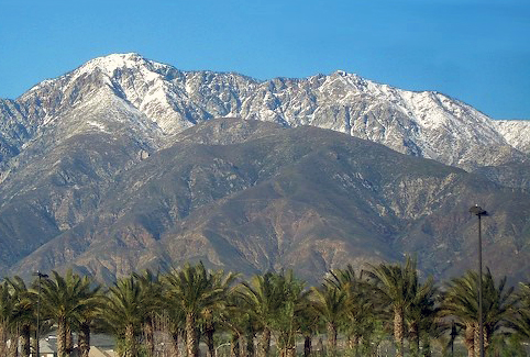
The mountains are close. Cucamonga Peak rises 8,862 feet above Rancho Cucamonga, a short canyon hike leads to the three-tier Etiwanda Falls, and Santa's Village, a mountain adventure park, sits up in Skyforest.

Practical note: this is busy suburban driving with many traffic lights, so allow extra time. Pasadena is about 40 miles further west.

Top 10 Route 66 attractions in and around San Bernardino

  1. Wigwam MotelNineteen tipi-shaped rooms on old Route 66: the last of the seven Wigwam Villages, and one of three left.
  2. Cucamonga Service StationThe last Route 66 gas station of its design left in California, right on Foothill Boulevard.
  3. PrometheusJosé Clemente Orozco's 1930 fresco at Pomona College, widely seen as America's earliest modern fresco.
  4. Madonna of the TrailA 1929 pioneer-mother statue, westernmost of 12 on the National Old Trails Road, beside the old Route 66.
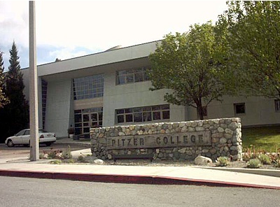
  5. John R. Rodman ArboretumA college arboretum on the Pitzer College campus, steps from other Claremont museums and landmarks.
  6. Tapia AdobeThe landmark home site of Tiburcio Tapia, who held the 1839 Rancho Cucamonga land grant.
  7. Ruth Chandler Williamson GalleryThe art gallery of Scripps College, set on a historic Spanish Colonial Revival campus in Claremont.
  8. Brackett ObservatoryPomona College's observatory, dating to 1908 and named for astronomy professor Frank Brackett.
  9. California Botanic Garden86 acres of California native plants below the San Gabriel foothills in Claremont.
  10. Santa's VillageA mountain adventure park in Skyforest on the grounds of a Santa's Village that ran from 1955 to 1998.
Wigwam Motel in Rialto, CA

Wigwam Motel

Rialto, California · on Route 66

Nineteen tipi-shaped rooms on old Route 66: the last of the seven Wigwam Villages, and one of three left.

Retro roadsidePhoto credit
Bono's Restaurant and Deli in Fontana, CA

Bono's Restaurant and Deli

Fontana, California · on Route 66

A 1940s Streamline Moderne roadside restaurant in Fontana, with a giant orange juice stand on the lot.

Retro roadsidePhoto credit
Cucamonga Service Station in Rancho Cucamonga, CA

Cucamonga Service Station

Rancho Cucamonga, California · on Route 66

The last Route 66 gas station of its design left in California, right on Foothill Boulevard.

Retro roadsidePhoto credit
Santa's Village in Lake Arrowhead, CA

Santa's Village

Lake Arrowhead, California · 10.4 mi from Route 66

A mountain adventure park in Skyforest on the grounds of a Santa's Village that ran from 1955 to 1998.

Art & landmarksPhoto credit

Robert Brownlee Observatory

Lake Arrowhead, California · 8.8 mi from Route 66

A mountain observatory in Lake Arrowhead run by a local astronomy society.

Art & landmarks
Tapia Adobe in Rancho Cucamonga, CA

Tapia Adobe

Rancho Cucamonga, California · 0.1 mi from Route 66

The landmark home site of Tiburcio Tapia, who held the 1839 Rancho Cucamonga land grant.

Art & landmarksPhoto credit
Madonna of the Trail in Upland, CA

Madonna of the Trail

Upland, California · on Route 66

A 1929 pioneer-mother statue, westernmost of 12 on the National Old Trails Road, beside the old Route 66.

Art & landmarksPhoto credit
Brackett Observatory in Claremont, CA

Brackett Observatory

Claremont, California · 0.6 mi from Route 66

Pomona College's observatory, dating to 1908 and named for astronomy professor Frank Brackett.

Art & landmarksPhoto credit
Prometheus in Claremont, CA

Prometheus

Claremont, California · 0.4 mi from Route 66

José Clemente Orozco's 1930 fresco at Pomona College, widely seen as America's earliest modern fresco.

Art & landmarksPhoto credit

Sawpit Canyon

Crestline, California · 5.6 mi from Route 66

A steep mountain canyon east of Monument Peak whose old creek mouth now lies under Silverwood Lake.

Nature & parks

Monument Peak

Crestline, California · 3.2 mi from Route 66

A 5,272-foot peak of the San Bernardino range, close to Sawpit and Devil canyons.

Nature & parks

Cajon Canyon

San Bernardino, California · 0.4 mi from Route 66

A long mountain valley that closes into a box canyon, named for the Spanish word for box.

Nature & parks
Devil Canyon in San Bernardino, CA

Devil Canyon

San Bernardino, California · 1.6 mi from Route 66

A steep canyon on the southern slope of Paivia Peak, draining toward the Santa Ana River.

Nature & parksPhoto credit
San Timoteo Canyon in Redlands, CA

San Timoteo Canyon

Redlands, California · 8.3 mi from Route 66

A river canyon southeast of Redlands, winding through the low hills of the San Jacinto range.

Nature & parksPhoto credit
Mount Jurupa in Jurupa Valley, CA

Mount Jurupa

Jurupa Valley, California · 5.2 mi from Route 66

The top of the Jurupa Mountains, with a summit trail and wide views over the Inland Empire.

Nature & parksPhoto credit
Jurupa Mountains in Jurupa Valley, CA

Jurupa Mountains

Jurupa Valley, California · 5.3 mi from Route 66

A small range of hills on the Riverside–San Bernardino county line in the Inland Empire.

Nature & parksPhoto credit

Etiwanda Falls

San Bernardino, California · 5.5 mi from Route 66

A three-tier waterfall about 50 feet tall, reached by a short canyon hike in Rancho Cucamonga.

Nature & parks
Cucamonga Peak near San Bernardino, CA

Cucamonga Peak

San Bernardino, California · 7.2 mi from Route 66

One of the highest peaks in the San Gabriel Mountains, rising 8,862 feet above Rancho Cucamonga.

Nature & parksPhoto credit
Potato Mountain near San Bernardino, CA

Potato Mountain

San Bernardino, California · 4.0 mi from Route 66

A foothill summit above Claremont on the southern front of the San Gabriel range.

Nature & parksPhoto credit
John R. Rodman Arboretum in Claremont, CA

John R. Rodman Arboretum

Claremont, California · 0.1 mi from Route 66

A college arboretum on the Pitzer College campus, steps from other Claremont museums and landmarks.

Nature & parksPhoto credit
California Botanic Garden in Claremont, CA

California Botanic Garden

Claremont, California · 0.3 mi from Route 66

86 acres of California native plants below the San Gabriel foothills in Claremont.

Nature & parksPhoto credit

Inland Empire Museum of Art

Upland, California · 0.3 mi from Route 66

A small nonprofit art museum in Pomona, founded in 2015 and now called the Sasse Museum of Art.

Museum

Ruth Chandler Williamson Gallery

Claremont, California · 0.1 mi from Route 66

The art gallery of Scripps College, set on a historic Spanish Colonial Revival campus in Claremont.

Museum
Benton Museum of Art in Claremont, CA

Benton Museum of Art

Claremont, California · 0.7 mi from Route 66

Pomona College's art museum, opened in 2020, with some 20,000 works from Renaissance panels to photographs.

MuseumPhoto credit
Padua Hills Theatre in Claremont, CA

Padua Hills Theatre

Claremont, California · 3.0 mi from Route 66

A Spanish Colonial Revival theater in the Claremont foothills with a long history of Mexican-theme musicals.

Historic theaterPhoto credit

Politana

Politana, California · 1.9 mi from Route 66

Where Spain first settled the San Bernardino Valley, starting as a mission outpost in 1810.

Ghost town

La Placita

La Placita, California · 6.0 mi from Route 66

The site of Riverside County's earliest community, settled on the Santa Ana River in the 1840s.

Ghost town
Russian Village District in Claremont, CA

Russian Village District

Claremont, California · 1.1 mi from Route 66

Fifteen handmade folk-style houses built during the Great Depression by a Polish immigrant and others.

Historic districtPhoto credit
John Rains House in Rancho Cucamonga, CA

John Rains House

Rancho Cucamonga, California · 0.3 mi from Route 66

An 1860s brick ranch house with a tale of wine, debt and murder, now a county history museum.

Historic buildingPhoto credit
Sam and Alfreda Maloof Compound in Rancho Cucamonga, CA

Sam and Alfreda Maloof Compound

Rancho Cucamonga, California · 3.7 mi from Route 66

The hand-built home and workshop of furniture maker Sam Maloof, now a museum devoted to Arts and Crafts.

Historic buildingPhoto credit
Frankish Building in Ontario, CA

Frankish Building

Ontario, California · 3.0 mi from Route 66

A three-story Renaissance Revival block from 1915–16, built by one of Ontario's founding promoters.

Historic buildingPhoto credit

Where to eat in and around San Bernardino

All diners on Route 66 →

Next towns on Route 66

Route 66 in San Bernardino: questions

Did Route 66 go through San Bernardino?
Yes. Route 66 came through San Bernardino after crossing Cajon Pass and continued west along Foothill Boulevard; the Cucamonga Service Station stands on that road in Rancho Cucamonga.
What is there to see on Route 66 in San Bernardino?
We list 31 stops in and around San Bernardino, mostly parks and nature areas, landmarks and roadside art and historic buildings. The ones our trip planner rates highest are Wigwam Motel, Cucamonga Service Station and Prometheus. Every stop is on the map above with a photo where one exists, and the distance from the old road.
How far is San Bernardino from the next towns on Route 66?
San Bernardino sits at about mile 2,384 of Route 66, counting from Chicago. The next town east with its own guide is Victorville, CA, about 56 miles back. Heading west, Pasadena, CA is about 31 miles on. Distances are measured along the road and rounded.
Is San Bernardino a good place to stay overnight on Route 66?
It works for a night. Our trip planner ends a day in San Bernardino when the day's miles fit, and otherwise prefers a bigger overnight town nearby.