
San Timoteo Canyon
- Nature & parks
- In Redlands, California
- 8.3 mi from Route 66
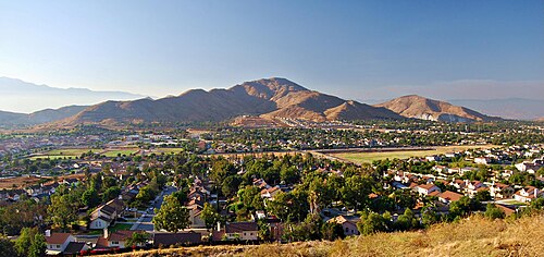
Carved by a river, San Timoteo Canyon lies near Redlands, CA, southeast of the city, about 7.3 miles off the old road. It winds through the low hills at the northwest tip of the San Jacinto range in the Inland Empire, crossing parts of both Riverside and San Bernardino counties. For Route 66 travelers, it is a quiet, open-country side trip away from the busy valley towns along the highway.
What is San Timoteo Canyon?
The canyon is a valley carved by a stream, with the low foothills of the San Jacinto range rising on either side. It spans the line between two counties.
Visiting San Timoteo Canyon: tips
Treat it as a scenic drive or short outing, and bring water in warm weather. The Politana ghost town site is about 6.7 miles away, and La Placita about 8.3 miles, for a pairing of scenery and history.
Practical info
- Address
- Redlands, CA 92373
- On site & nearby
Sources: OpenStreetMap contributors (ODbL) · Wikidata · official site — may be outdated. Suggest a fix
Where to eat near San Timoteo Canyon
All diners on Route 66 →
On the map
Full mapSan Timoteo Canyon with the 6 closest stops and a place to eat (fork and knife). Tap a marker for details.
Tap a dot to see that stop here.
Stops near San Timoteo Canyon
All of California6.7 mi from San Timoteo Canyon
8.3 mi from San Timoteo Canyon

9.9 mi from San Timoteo Canyon
13.6 mi from San Timoteo Canyon

13.8 mi from San Timoteo Canyon
13.9 mi from San Timoteo Canyon
Own or run San Timoteo Canyon? Send us a photo or a correction.